 Follow Nordpil on Twitter!
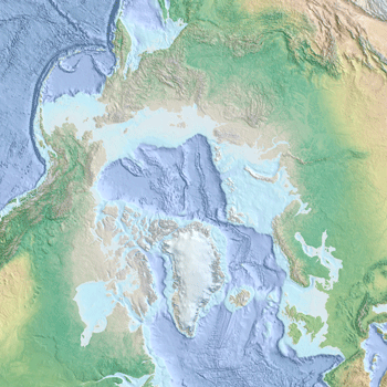
Arctic ocean basemap for UNEP Shelf Programme

 The UNEP Shelf Programme, a
division of UNEP/GRID-Arendal, provides support to developing countries in their claims to the
UN Convention on the Law of the Sea (UNCLOS) regarding their continental shelf areas.
The UNEP Shelf Programme, a
division of UNEP/GRID-Arendal, provides support to developing countries in their claims to the
UN Convention on the Law of the Sea (UNCLOS) regarding their continental shelf areas.
For an upcoming online data service, the UNEP Shelf Programme turned to Nordpil to prepare a high-resolution basemap as background information. The map requirements specified best available arctic and global data sources, muted colors for background display, and the capacity to enable overlays of thematic data.
The data was prepared using data sources such as CleanTopo2, Natural Earth, GEBCO and IBCAO, and set up as three extremely high-resolution images on different scale levels. These datasets enable continous zooming from a circumpolar pan-Arctic view down to close-up large-scale map display.
Topography and bathymetry were presented using cross-blended hypsometric tints (land areas) and simple elevation-based hypsometric tints for marine areas.
The final data was registered, loaded onto the UNEP/GRID-Arendal ArcGIS ArcSDE server and enabled using ArcGIS Server, including an OpenGIS Consortium (OGC) Web Map Service (WMS) interface.
For more information, please refer to the UNEP Shelf Programme at UNEP/GRID-Arendal