 Follow Nordpil on Twitter!
Globalis - interactive map on development and our world
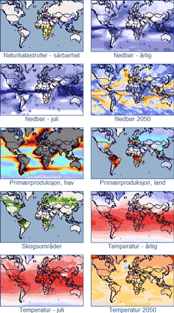 The Norwegian website Globalis presents the
world with facts and figures on development and environment. The website is targeted at
schoolchildren and educators, and is hosted by the Norwegian UN Association. Nordpil assisted
the project by preparing updated map layers for the map component in the first half of 2010.
The Norwegian website Globalis presents the
world with facts and figures on development and environment. The website is targeted at
schoolchildren and educators, and is hosted by the Norwegian UN Association. Nordpil assisted
the project by preparing updated map layers for the map component in the first half of 2010.
The map component of Globalis, developed by the Norwegian UN Association, makes extensive use of Open Layers and JavaScript to present the interactive maps, in addition to base map data and information from Google Maps.
The map data, prepared by Nordpil, was researched and selected in cooperation with the client. Data was acquired and transformed using ESRI ArcGIS and GlobalMapper. The cartography and map design were selected to complement additional information and existing layers in Globalis.
To view and
explore the world maps in Globalis,
please refer to http://www.globalis.no/Verdenskart