 Follow Nordpil on Twitter!
Dniester river basin interactive map
 Government officers from Ukraine and Moldova
cooperated to assemble a transboundary geographic database for the Dniester river basin. The
basin covers both of these countries, including the Transnistria region of Moldova. The river
drains to the Black Sea.
Government officers from Ukraine and Moldova
cooperated to assemble a transboundary geographic database for the Dniester river basin. The
basin covers both of these countries, including the Transnistria region of Moldova. The river
drains to the Black Sea.
The database covers themes with environmental parameters, as well as background basemap data layers. Using the database, it is possible to analyze the region to support better decision-making for population, pollution, conservation and international issues.
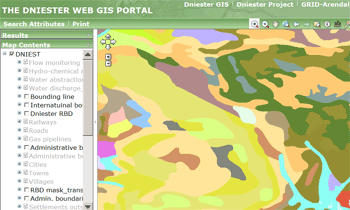
To present the data and make it more accessible, Zoï prepared an interactive map using ESRI ArcGIS Server. Nordpil was responsible for setting up and configuring the backend powering the map, using ESRI ArcSDE and ArcGIS Server. All cartography and web development were prepared by Zoï. The map was prepared together with UNEP/GRID-Arendal, which also hosts it.
The map is available in both Russian and English at
http://maps.grida.no/dniester/viewer.htm