 Follow Nordpil on Twitter!
Uganda biofuels atlas - interactive map
 Biofuel, conservation and
food crops in Uganda - An assessment of land resources for biofuel feedstock
suitability
Biofuel, conservation and
food crops in Uganda - An assessment of land resources for biofuel feedstock
suitability
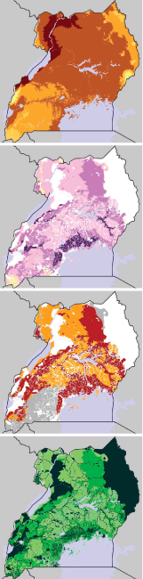
This interactive map presents the results from a study conducted under the framework of the
Uganda National Environment Information Network with a major objective of assessing the
land resources suitable for production of biofuels and identifying relevant policy options that
seek to integrate biofuel feedstock production into the land use planning process.
The potential competition for resources between biofuel feedstocks and food crops, and
consequent increased food insecurity, gives rise to a need to develop synergistic inter-
sectoral polices to guide sustainable development of biofuels in Uganda. Lack of appropriate
policy support for small-scale biofuel development at the local level may slow down the progress
of the biofuel programs.
The study and analysis presented in this interactive map were executed by the National
Environment Management Authority (NEMA) of Uganda. The report is available upon
request.
The map, including map server setup and configuration, web development and cartography, was prepared by Nordpil for UNEP/GRID-Arendal. The map is based on the ESRI ArcIMS map server software and utilizes extensive JavaScript technologies to leverage the data, prepared as raster layers deployed in an enterprise geodata server - powered by ESRI ArcSDE.