 Follow Nordpil on Twitter!
February 27, 2012
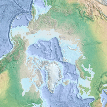
Arctic ocean basemap in portfolio

 The United Nations Environment Programme (UNEP) Continental
Shelf Programme, a part of UNEP/GRID-Arendal commissioned
Nordpil to prepare a very detailed map of the marine greater Arctic.
The United Nations Environment Programme (UNEP) Continental
Shelf Programme, a part of UNEP/GRID-Arendal commissioned
Nordpil to prepare a very detailed map of the marine greater Arctic.
The resulting map was published online using an Open GIS Web Map Service (OGC WMC) utilizing ESRI
ArcGIS Server.
The Arctic Ocean basemap has now been added to the portfolio pages on this website as a
demonstration of work produced by Nordpil.