 Follow Nordpil on Twitter!
Revised web maps for UNEP/GRID-Arendal

 UNEP/GRID-Arendal,
an institution linked to the UN Environment Programme, has a collection of interactive web maps
dating back almost 15 years.
UNEP/GRID-Arendal,
an institution linked to the UN Environment Programme, has a collection of interactive web maps
dating back almost 15 years.
The maps were previously been designed and deployed using ESRI ArcIMS 9 with ArcSDE and custom JavaScript/DHTML viewers.
Hugo Ahlenius of Nordpil was contracted to migrate these maps to a contemporary platform.
The data was migrated from ArcSDE to ESRI ArcGIS file geodatabases, and the maps were re-created in ArcMap as mxd-files, then deployed on ArcGIS Server as dynamic map services.
The web interfaces were then built using the ArcGIS JavaScript API and the Dōjō framework, in a template similar to that used in the previous web interface.
The new map views have increased performance, more interactive features and full compatibility with modern web browsers, including for phones and tablets, without any dependencies on plugins such as Flash and Silverlight.
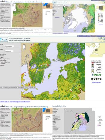
The map services are:
- Arctic Environmental Atlas
- Baltic Environmental Atlas
- Uganda Biofuels Atlas
-
DatabasiN - Daugava/Zapadnaya Dvina river basin interactive map
-
DatabasiN - Nemunas/Neman river basin interactive map
For more information, please see the UNEP/GRID-Arendal website: