 Follow Nordpil on Twitter!
Tectonic plates GIS data

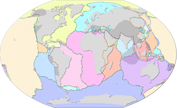 The best
freely available dataset on tectonic plates, orogens and plate boundaries was published in 2003
by Peter Bird (formerly University of California).
The best
freely available dataset on tectonic plates, orogens and plate boundaries was published in 2003
by Peter Bird (formerly University of California).
The data was originally published in the paper An updated digital model of plate boundaries (Geochemistry Geophysics Geosystems, 4(3), 1027, doi:10.1029/2001GC000252, 2003). The dataset is available for free unrestricted download, currently from the researcher's private website. However, it is only available in a complicated text format, meaning that it is not easily accessible for use in GIS applications.
To bring this dataset into the modern age, the original data has been parsed, cleaned and verified using ArcGIS 10.2 and converted to shape files.
All the original data were retrieved from http://peterbird.name/oldFTP/PB2002/ in June 2014, and parsed using Python and Global Mapper 11. Further data manipulation was performed in ArcGIS 10.2. The main edits regarded segments spanning the -180/180 boundary, which had to be manually split and moved.
This collection is made available under the Open Data Commons Attribution License, which puts few restrictions on the use of the data.
The dataset presents tectonic plates and their boundaries, as well as orogens and information about the boundaries. The data is useful for geological applications, analysis and education, and should be easy to use in any modern GIS software application. For information on the fields and values, please refer to the original documentation and the scientific article.
For more information and download links, please refer to the
GitHub repository for the database:
https://github.com/fraxen/tectonicplates