 Follow Nordpil on Twitter!
Web
Nordpil has prepared websites ranging from the simple text-based pages to interactive websites with graphics and statistics databases. Services include web-based interactive maps using modern technologies. Some of these websites have risen to very high rankings and attracted some 100 000 visitors per month.
2015
-
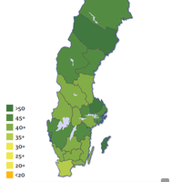
Pappaindex, interactive map
-
November 1, 2015
Interactive map to visualize statistics on gender equality and parental leave in
Sweden. The client is TCO, one of the larger unions in Sweden. The map, which
allows zooming and inspecting the situation at municipal level and annual
statistics from 2000-2014, was implemented using the D3 javascript library, and
is fully rendering charts and maps in the web browser client. The application is
also fully responsive, and is displays equally well on mobile devices as on
desktop computers. The application is accessible at: http://www.tco.se/var-politik/Jamstalldhet-och-mangfald/Pappaindex/Pappaindex-statistikkarta/.
-
2014
-
Sustaining Arctic Observing Networks (SAON) inventory database

-
December 1, 2014
The inventory acts as a clearinghouse on infrastructure, stations and
programmes for pollution, biodiversty, climate and other environmental
parameters for the circumpolar Arctic. Nordpil summarized national reports
into a database, which has now been web-enabled.
-
-
Other Web

-
- Arctic Monitoring and Assessment
Programme (AMAP) video library, containing videos on
pollution and climate change in the Arctic. Nordpil assisted the
client in documenting and uploading videos, in addition to
structuring the library.
- Geoportal of the Dniester River
Basin, A database of spatial data for the joint management
of the Dniester river basin, covering the countries of Moldova and
Ukraine, including the Transnistria region. The portal includes
interactive maps and the river basin atlas and is available in
English and Russian. Nordpil migrated the application, using linux,
ESRI ArcGIS Server, ESRI Geoportal Server and Joomla to a new
virtual machine including updates and maintenance.
- UNEP Shelf One Stop Data
Shop, interactive map for reviewing geological data for
ocean areas. The map service has been implemented by Nordpil in ESRI
ArcIMS (2006-2012) and later moved to ESRI ArcGIS Server Javascript
API (2012-). The client was the United Nations Environment Programme
(UNEP) Continental Shelf unit.
Cartography, web design, javascript programming.
- Globalis (rainforest
portal), a resource on the importance of tropical
rainforests for the global system, and their relationship to climate
change. The portal is part of the Globalis information service on
sustainable development issues. The website is run by the Norwegian
UN Assocation, and has high-school students as the primary target
group.
Illustrations and preparation, design and cartography for global
map views.
- Globalis
(biodiversity portal), a section of the Globalis information
service covering all aspects of biodiversity, ecology and
conservation (in Norwegian). The service is managed by the Norwegian
UN Association.
Illustrations and preparation, design and cartography for global
map views.
- Dniester river
basin interactive map, prepared for UNEP/GRID-Arendal in
cooperation with Zoï Environment.
Interactive map powered by ESRI ArcGIS Server and
ESRI ArcSDE.
- Uganda
biofuels atlas, interactive map prepared for
UNEP/GRID-Arendal.
Interactive map powered by ESRI ArcIMS and
ESRI ArcSDE.
- Globalis (Norwegian), an
interactive information system on our shared world, with a focus on
environment and development issues.
Preparation, design and cartography of the data for the map
views.
- Prototype project for data and indicator resources (UNEP/DEWA)
Draft web design in a discussion template, using Mura CMS,
ColdFusion/Open BlueDragon, Tomcat, Apache.
- University of the Arctic Atlas (map viewer)
- UNEP/GRID-Arendal maps and graphics
library
- Arctic Environmental
Atlas
- Baltic Environmental
Atlas
- Globalis, interactive map and statistics database in collaboration
with GVU (United Nations University), UNEP/GRID-Arendal and the
Norwegian UN-ASsociation. The service included content management
interface and digital asset management.
Website development, management interface, map service set in
Adobe ColdFusion, ESRI ArcIMS and ESRI ArcSDE. Service no longer
accessible, previously at http://globalis.gvu.unu.edu/
- Arctic Monitoring and Assessment
Programme (AMAP)
- Poverty Mapping, website, map database, resource catalog and link
database for a joint FAO, UNEP/GRID-Arendal and CGIAR-CSI
project.
Programmed in Adobe ColdFusion, service no longer accessible,
previously at http://povertymap.net
- GLOBIO
- UNEP/GRID-Arendal
- Arctic Parliamentarians
- Conservation Finance Alliance guide
- Baltic GIS
- UNEP.Net
Interactive map to visualize statistics on gender equality and parental leave in Sweden. The client is TCO, one of the larger unions in Sweden. The map, which allows zooming and inspecting the situation at municipal level and annual statistics from 2000-2014, was implemented using the D3 javascript library, and is fully rendering charts and maps in the web browser client. The application is also fully responsive, and is displays equally well on mobile devices as on desktop computers. The application is accessible at: http://www.tco.se/var-politik/Jamstalldhet-och-mangfald/Pappaindex/Pappaindex-statistikkarta/.
-
Sustaining Arctic Observing Networks (SAON) inventory database
-
December 1, 2014
The inventory acts as a clearinghouse on infrastructure, stations and programmes for pollution, biodiversty, climate and other environmental parameters for the circumpolar Arctic. Nordpil summarized national reports into a database, which has now been web-enabled.
-
Other Web
-
- Arctic Monitoring and Assessment
Programme (AMAP) video library, containing videos on
pollution and climate change in the Arctic. Nordpil assisted the
client in documenting and uploading videos, in addition to
structuring the library.
- Geoportal of the Dniester River
Basin, A database of spatial data for the joint management
of the Dniester river basin, covering the countries of Moldova and
Ukraine, including the Transnistria region. The portal includes
interactive maps and the river basin atlas and is available in
English and Russian. Nordpil migrated the application, using linux,
ESRI ArcGIS Server, ESRI Geoportal Server and Joomla to a new
virtual machine including updates and maintenance.
- UNEP Shelf One Stop Data
Shop, interactive map for reviewing geological data for
ocean areas. The map service has been implemented by Nordpil in ESRI
ArcIMS (2006-2012) and later moved to ESRI ArcGIS Server Javascript
API (2012-). The client was the United Nations Environment Programme
(UNEP) Continental Shelf unit.
Cartography, web design, javascript programming.
- Globalis (rainforest
portal), a resource on the importance of tropical
rainforests for the global system, and their relationship to climate
change. The portal is part of the Globalis information service on
sustainable development issues. The website is run by the Norwegian
UN Assocation, and has high-school students as the primary target
group.
Illustrations and preparation, design and cartography for global
map views.
- Globalis
(biodiversity portal), a section of the Globalis information
service covering all aspects of biodiversity, ecology and
conservation (in Norwegian). The service is managed by the Norwegian
UN Association.
Illustrations and preparation, design and cartography for global
map views.
- Dniester river
basin interactive map, prepared for UNEP/GRID-Arendal in
cooperation with Zoï Environment.
Interactive map powered by ESRI ArcGIS Server and
ESRI ArcSDE.
- Uganda
biofuels atlas, interactive map prepared for
UNEP/GRID-Arendal.
Interactive map powered by ESRI ArcIMS and
ESRI ArcSDE.
- Globalis (Norwegian), an
interactive information system on our shared world, with a focus on
environment and development issues.
Preparation, design and cartography of the data for the map
views.
- Prototype project for data and indicator resources (UNEP/DEWA)
Draft web design in a discussion template, using Mura CMS,
ColdFusion/Open BlueDragon, Tomcat, Apache.
- University of the Arctic Atlas (map viewer)
- UNEP/GRID-Arendal maps and graphics
library
- Arctic Environmental
Atlas
- Baltic Environmental
Atlas
- Globalis, interactive map and statistics database in collaboration
with GVU (United Nations University), UNEP/GRID-Arendal and the
Norwegian UN-ASsociation. The service included content management
interface and digital asset management.
Website development, management interface, map service set in
Adobe ColdFusion, ESRI ArcIMS and ESRI ArcSDE. Service no longer
accessible, previously at http://globalis.gvu.unu.edu/
- Arctic Monitoring and Assessment
Programme (AMAP)
- Poverty Mapping, website, map database, resource catalog and link
database for a joint FAO, UNEP/GRID-Arendal and CGIAR-CSI
project.
Programmed in Adobe ColdFusion, service no longer accessible,
previously at http://povertymap.net
- GLOBIO
- UNEP/GRID-Arendal
- Arctic Parliamentarians
- Conservation Finance Alliance guide
- Baltic GIS
- UNEP.Net
- Arctic Monitoring and Assessment Programme (AMAP) video library, containing videos on pollution and climate change in the Arctic. Nordpil assisted the client in documenting and uploading videos, in addition to structuring the library.
- Geoportal of the Dniester River Basin, A database of spatial data for the joint management of the Dniester river basin, covering the countries of Moldova and Ukraine, including the Transnistria region. The portal includes interactive maps and the river basin atlas and is available in English and Russian. Nordpil migrated the application, using linux, ESRI ArcGIS Server, ESRI Geoportal Server and Joomla to a new virtual machine including updates and maintenance.
- UNEP Shelf One Stop Data
Shop, interactive map for reviewing geological data for
ocean areas. The map service has been implemented by Nordpil in ESRI
ArcIMS (2006-2012) and later moved to ESRI ArcGIS Server Javascript
API (2012-). The client was the United Nations Environment Programme
(UNEP) Continental Shelf unit.
Cartography, web design, javascript programming. - Globalis (rainforest
portal), a resource on the importance of tropical
rainforests for the global system, and their relationship to climate
change. The portal is part of the Globalis information service on
sustainable development issues. The website is run by the Norwegian
UN Assocation, and has high-school students as the primary target
group.
Illustrations and preparation, design and cartography for global map views. - Globalis
(biodiversity portal), a section of the Globalis information
service covering all aspects of biodiversity, ecology and
conservation (in Norwegian). The service is managed by the Norwegian
UN Association.
Illustrations and preparation, design and cartography for global map views. - Dniester river
basin interactive map, prepared for UNEP/GRID-Arendal in
cooperation with Zoï Environment.
Interactive map powered by ESRI ArcGIS Server and ESRI ArcSDE. - Uganda
biofuels atlas, interactive map prepared for
UNEP/GRID-Arendal.
Interactive map powered by ESRI ArcIMS and ESRI ArcSDE. - Globalis (Norwegian), an
interactive information system on our shared world, with a focus on
environment and development issues.
Preparation, design and cartography of the data for the map views. - Prototype project for data and indicator resources (UNEP/DEWA)
Draft web design in a discussion template, using Mura CMS, ColdFusion/Open BlueDragon, Tomcat, Apache. - University of the Arctic Atlas (map viewer)
- UNEP/GRID-Arendal maps and graphics library
- Arctic Environmental Atlas
- Baltic Environmental Atlas
- Globalis, interactive map and statistics database in collaboration
with GVU (United Nations University), UNEP/GRID-Arendal and the
Norwegian UN-ASsociation. The service included content management
interface and digital asset management.
Website development, management interface, map service set in Adobe ColdFusion, ESRI ArcIMS and ESRI ArcSDE. Service no longer accessible, previously at http://globalis.gvu.unu.edu/ - Arctic Monitoring and Assessment Programme (AMAP)
- Poverty Mapping, website, map database, resource catalog and link
database for a joint FAO, UNEP/GRID-Arendal and CGIAR-CSI
project.
Programmed in Adobe ColdFusion, service no longer accessible, previously at http://povertymap.net - GLOBIO
- UNEP/GRID-Arendal
- Arctic Parliamentarians
- Conservation Finance Alliance guide
- Baltic GIS
- UNEP.Net