 Follow Nordpil on Twitter!
Interactive ArcGIS map for UNEP

 The United Nations Environment Programme (UNEP) Continental
Shelf Programme, a part of UNEP/GRID-Arendal commissioned
Nordpil to upgrade their existing ESRI ArcIMS interactive map to ESRI ArcGIS Server 10, building
a map viewer using the Javascript API.
The United Nations Environment Programme (UNEP) Continental
Shelf Programme, a part of UNEP/GRID-Arendal commissioned
Nordpil to upgrade their existing ESRI ArcIMS interactive map to ESRI ArcGIS Server 10, building
a map viewer using the Javascript API.
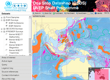
The UNEP Shelf Programme One Stop Datashop presents a wealth of scientific geological ocean survey data, and lets the users browse and explore the data repository. The data is provided by a wide variety of oceanographic institutions, including IFREMER, NOAA and the Woods Hole Oceanographic Institution.
Behind the map sits a stack of ESRI ArcGIS Server, including the enterprise ArcSDE geodatabase. The map viewer, in the user's web browser, is utilizing the ArcGIS Javascript API to enable display, interaction and querying of the map.
The map is also available in both a global world projection and in a separate Arctic polar view, interfacing the same data.
The UNEP
Shelf Programme One Stop Datashop is available at:
http://maps.continentalshelf.org/