 Follow Nordpil on Twitter!
July 4, 2014
New Wagner VII GIS database

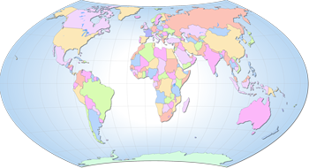 Nordpil is proud to announce the Wagner VII basemap
database. This collection of GIS data is now publicly available for
download and integration in cartographic outputs and projects. The data is modified from the
Natural Earth 2.0 dataset and reprojected and edited. Wagner VII is an equal-area
projection suitable for thematic world maps.
Nordpil is proud to announce the Wagner VII basemap
database. This collection of GIS data is now publicly available for
download and integration in cartographic outputs and projects. The data is modified from the
Natural Earth 2.0 dataset and reprojected and edited. Wagner VII is an equal-area
projection suitable for thematic world maps.
The data, available for download through GitHub, is released under a public domain license for unrestricted usage.
Read more in the resources section:
https://nordpil.com/resources/wagner-vii-gis-data/