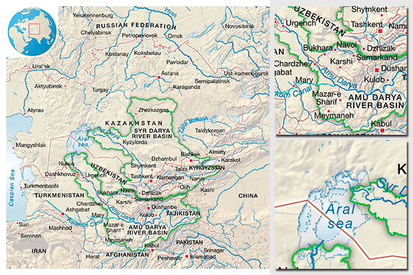
Central Asia - Aral Sea and surrounding area
Map originally prepared for a SIWI regional report, to introduce the area, and to provide an overview of the main water issues in the region.
The topographic background was prepared as a shaded relief using the CleanTopo2 elevation model, assembled by Tom Patterson. Hydrology was modified from the ArcWorld collection from ESRI, and the administrative boundaries and cities were drawn from the ESRI Data & Maps 2008 database. The drainage basins are from the GDBD collection.
The software used in this map production was ESRI ArcGIS and Adobe Illustrator.
Data source references:
- Patterson, T. 2006. CleanTOPO2. http://www.shadedrelief.com/cleantopo2/ (accessed June 20, 2008)
- ESRI Inc. 1992. ArcWorld 1:3 million CD-Rom. Redlands, USA: ESRI.
- ESRI Inc. 2008. ESRI Data & Maps 2008. Redlands, USA: ESRI.
- Center for Global Environmental Research. 2007. Global Drainage Basin Database (GDBD) v1. http://www.cger.nies.go.jp/db/gdbd/gdbd_index_e.html (accessed April 22, 2009)
Do you need powerful, clear and good-looking illustrations?
Nordpil specializes in creating the best maps, charts and diagrams for high-profile publications, please contact us and describe your needs, and we will get back to you with a quote.
Would you like to learn how to prepare better maps, charts and diagrams?
In our training workshops you will learn about the theory about creating powerful visual material based on scientific data and statistics, and we discuss and deconstruct examples from recent publications, news and your work. Read more on our workshop pages.
 Follow Nordpil on Twitter!
