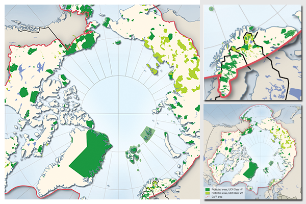
Protected areas of the Arctic
National parks and other protected areas play an important role in the protection of our fragile environment. By establishing these land and marine areas and reducing the human impact on them, we create important sanctuaries for wildlife, ecosystems and the biosphere. Protected areas are not only refuges for birds, mammals and insects - but are also important for tourism and local economies.
The Arctic represents an area of the world that has seen very little human impact so far. The study for which this map was prepared examines the current status and coverage of environmental protection in the circumpolar north.
Map prepared as overview for an inventory of protected areas in the Arctic, for Conservation of Arctic Flora and Fauna (CAFF) working group of the Arctic Council
The map uses a Lambert Azimuthal Equal Area projection, centered on the North Pole.
ESRI ArcGIS and Adobe Illustrator were used to prepare the map. The base map data was prepared from the Natural Earth database. Data on protected areas was provided through the Conservation of Arctic Flora and Fauna (CAFF) network.
For more information, please refer to:
- CAFF Monitoring Series Report No.5 - Circumpolar Protected Areas Monitoring Arctic Protected Areas Monitoring Scheme Background Paper (Arctic Portal)
- Conservation of Arctic Flora and Fauna (CAFF) working group of the Arctic Council
Do you need powerful, clear and good-looking illustrations?
Nordpil specializes in creating the best maps, charts and diagrams for high-profile publications, please contact us and describe your needs, and we will get back to you with a quote.
Would you like to learn how to prepare better maps, charts and diagrams?
In our training workshops you will learn about the theory about creating powerful visual material based on scientific data and statistics, and we discuss and deconstruct examples from recent publications, news and your work. Read more on our workshop pages.
 Follow Nordpil on Twitter!
