Red knot migration
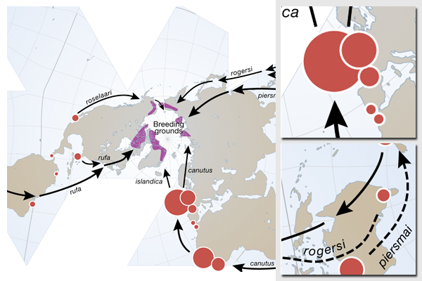
The red knot, Calidris canutus, is a migratory shorebird that travels long distances. This map presents the breeding areas and migratory routes of six recognized subspecies of the red knot. All breeding areas (dark purple shading) are in the high Arctic, where adult individuals spend the summer. After their long-distance migrations, they spend the rest of the year mainly in coastal areas (red dots, scaled to approximate population size).
Map illustration for Arctic Biodiversity Trends 2010, an overview report for the Arctic Biodiversity Assessment. This assessment is an activity under the Arctic Council, and is coordinated by the Conservation of Arctic Flora and Fauna (CAFF) program.
The map uses the Fuller/Dymaxion projection.
ESRI ArcGIS and Adobe Illustrator were used to prepare the map. The base map data was prepared from the Natural Earth database.
For more information, please refer to:
- This map, published on the UNEP/GRID-Arendal website
- Arctic Biodiversity Trends 2010 website
- Conservation of Arctic Flora and Fauna
Do you need powerful, clear and good-looking illustrations?
Nordpil specializes in creating the best maps, charts and diagrams for high-profile publications, please contact us and describe your needs, and we will get back to you with a quote.
Would you like to learn how to prepare better maps, charts and diagrams?
In our training workshops you will learn about the theory about creating powerful visual material based on scientific data and statistics, and we discuss and deconstruct examples from recent publications, news and your work. Read more on our workshop pages.
 Follow Nordpil on Twitter!
